

Role
2022 Cohort for Design and Innovation for Sustainable Cities
Skills
Site Research
Urban Design
Physical Prototyping
Timeline
July 2022 - Aug. 2022 (7 weeks)
Tools
Adobe Creative Cloud
Rhino
ArcGIS
Project Background
Decades of discriminatory policy, including redlining and the construction of polluting infrastructure (like highways and ports), led to the mass displacement of residents in West Oakland, concentrated poverty, and chronic health issues, making the community exceptionally susceptible to climate impacts like extreme heat, flooding, and degraded air quality. This history means that any climate action implemented without a focus on equity risks exacerbating past harms, potentially triggering "green gentrification" and further displacement.
This project is therefore dedicated to achieving climate resilience through restorative justice. It aims to implement climate mitigation and adaptation strategies—such as expanding urban green space —while simultaneously integrating robust anti-displacement measures. By creating a multi-modal transportation hub, embedding community ownership, and securing housing stability, the project ensures that climate investments directly benefit and empower long-term, historically impacted residents, thereby healing past wounds while building a truly secure and equitable future.
Understanding the History of West Oakland
01
Harlem of the West
Imagine walking down Seventh St. in Oakland in the 1940s, immersed in a vibrant community centered around the emerging Jazz and Blues scene. The streets are alive with music, and the air is filled with the spirit of community upliftment, driven by the pioneering efforts of the Black Panther Party. People are engaged, inspired, and working together to build a stronger, more resilient neighborhood.
Previously, in West Oakland...
Therefore, we asked...
How might we remodel West Oakland's transit hub to design for future climate resilience and community ownership, while making sure to address the current residents' needs and pain points?
Disguised Displacement
After the war, West Oakland lost its wartime production jobs, and rail travel declined with the rise of automobiles. The intra-city trains, which once brought people to the neighborhood, subsequently diminished, leading to the closure of local businesses. One resident recalls, “the businesses closed down, the streets looked shabby.” Black homeowners in this redlined neighborhood struggled to get repair loans from banks.
Soon, "urban renewal" became a focus. City administrators equated renewal with redevelopment, which completely reshaped the community as the government seized property for public use.
It started with the Nimitz Interstate Freeway that completely destroyed hundreds of homes, mainly occupied by the African-American community. A few years later, hundreds of homes across a 20-acre area were demolished to construct the nearly one-million-square-foot US Post Office regional distribution center on 7th Street. In 1974, the opening of BART’s West Oakland station "decimated" half of the business district along 7th Street.


West Oakland in 2022
02
From Big Picture to Small
Our project started by acknowledging West Oakland's history—a story of systemic policy that dismantled the vibrant African-American community and its cultural hubs.
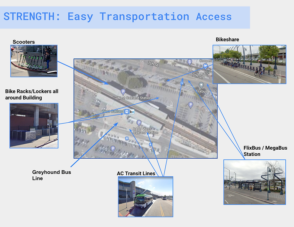
To pursue restorative justice, we needed to understand the 'big picture' down to the individual. Therefore, we first conducted a site analysis by walking around the area and talking to residents, small businesses, and people passing by. At first glance, we can clearly see the remnants of urban renewal. Instead of a lively hub, we encountered disconnected infrastructure, oversized industrial centers, and wide, empty roads. These planning decisions have left behind an environment where underutilized vacant lots sit next to long-standing homes, creating an atmosphere that feels transient and isolating rather than rooted and communal. The immediate area surrounding the West Oakland BART Station exemplifies the neighborhood's fragmented landscape, a direct result of mid-20th-century planning that prioritized traffic over community.
We then conducted a specific SWOT analysis to link these physical weaknesses to resident pain points like displacement and air pollution. Finally, by talking to residents, small businesses, and individuals (micro-level), we grounded our vision in community needs.


.png)

Key Insights
1. Climate Resilience as an Anti-Gentrification Strategy
If our project successfully implements resilience measures (e.g., green infrastructure to mitigate flooding and heat), the increased property values could displace the very residents the project was meant to protect. Therefore, resilience investments (especially flood and heat mitigation) must be paired with immediate anti-displacement mechanisms (like community land trusts or permanent rent caps) to ensure stability for long-term residents.
2. Reversing Displacement Requires Anchoring Community and Culture in Land Ownership
The historical trauma was a loss of land, businesses, and cultural centers. True revitalization requires physically reversing this loss by creating new, permanent community assets on historically significant or neglected land. Therefore, restorative justice must focus on repurposing underutilized land to create communally owned assets (such as nature areas, public spaces, affordable housing, and cultural centers) that legally and permanently link the physical resilience of the land with the economic stability and cultural memory of long-term residents.
3. Planning Must Link Present Crises to Future Threats
While our project must address the trauma and needs identified today, it is fundamentally designed to prevent more catastrophic losses tomorrow. Therefore, solutions must be multi-benefit designs that solve both: addressing immediate community needs (e.g., green spaces that combat heat and are communally owned) while simultaneously mitigating long-term climate threats (e.g., sea-level rise and extreme heat).
Getting to the Final Idea
03
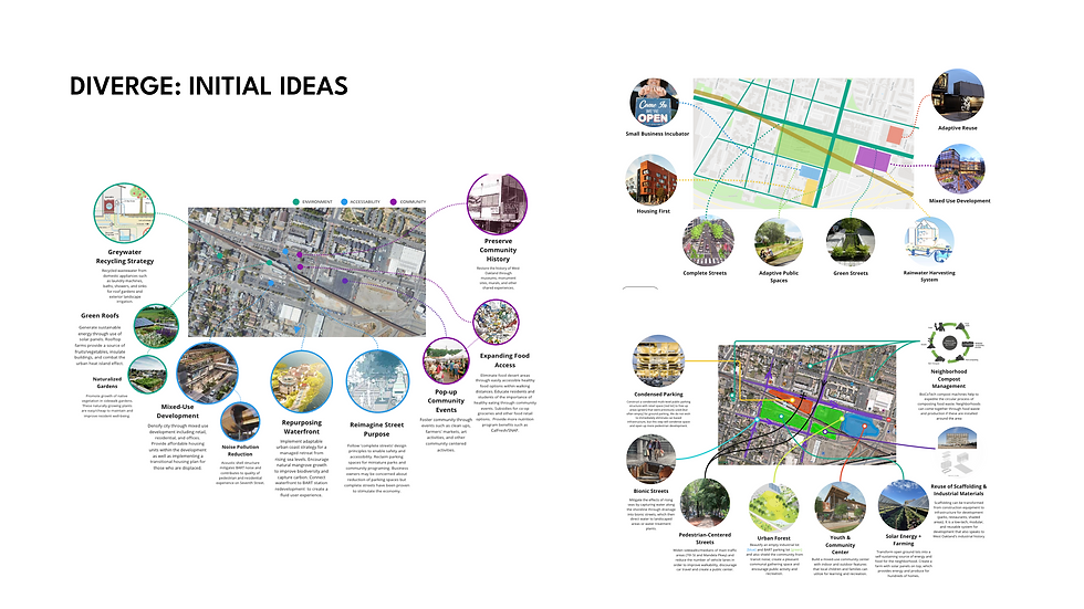
Let's (literally) diverge, then converge
I had the privilege of collaborating with a diverse, international team of students. While we quickly aligned on the problem's core ethical and historical foundation, we decided to use a 'Diverge and Converge' strategy: we split up to maximize individual ideation, drawing on our varied expertise. We then re-grouped to synthesize our separate approaches into a single, comprehensive final concept.


Final Idea...ish?
Despite our diverse visual approaches—each of us producing distinctly different perspective drawings —a few core ideas consistently emerged from our separate ideation sessions.
Upon discussion, we realized the biggest existential challenge for West Oakland over the next century is accelerating sea-level rise and its amplified flooding risk. This led us to develop our core resilience strategy: transforming West Oakland into a 'sponge city'—a high-level concept that would guide all physical interventions.
Beyond this resilience mandate, our final design concept integrated the most impactful ideas directly supporting our Key Insights for economic and social justice. These concepts include Mixed-Use Development (for local job creation and housing stability), Adaptive Public Spaces (for cultural permanence and anti-displacement), and Complete Streets (to repair the fragmented landscape and prioritize people over traffic).
But how...?
.png)
FINAL IDEA
1. Resilience Strategy
The core of our intervention is the 'West Oakland Waterfront'—a resilient solution that strategically embraces sea-level rise rather than resisting it. We arrived at this concept after developing and analyzing three distinct scenarios for embracing sea level rise.
This vision transforms West Oakland into a Sponge City by integrating Nature-Based Solutions to combat climate change, specifically by bringing down local temperatures, cleaning stormwater runoff, and significantly reducing flood risk.
Key physical interventions include:
-
Green Infrastructure: Extensive green roofs and permeable pavements on sidewalks and streets to maximize water absorption.
-
Water Management: Two man-made lakes connected by a canal to absorb rising tides and simultaneously create new space for recreation and tourism.
2. Community and Economic Anchors
-
Adaptive Development: Housing and commercial buildings along the canal will be elevated on stilts. This creates temporary covered event spaces below, which will transition from parking to uses like farmer’s markets and pop-up retail as West Oakland evolves into a car-free community.
-
Mobility and Walkability: We revitalize the historic 7th Street corridor with ground-level retail to encourage a walkable lifestyle. Protected bike lanes and Bus Rapid Transit (BRT) will make the neighborhood highly accessible. People are able to walk to the BART station as well.
-
Cultural Centerpiece: The entire waterfront area is designed as a centerpiece to physically reconnect the community, celebrating its past, present, and future and allowing residents to thrive for generations.


Reflections...


First of all, I want to extend a special thanks to Gabriel Tenaya Kaprielian, Reagan Lauder, and Dewi Bleher for leading such a transformative program and being incredible guides through the complexities of this discipline. Finally, I’m grateful to my teammates, Herman and Matthew, for their patience and partnership with me as a newbie in this field, and to Chester Ling for his friendship, mentorship, and for being such a great role model.
As a student with a keen interest in Creativity and Cities, but no experience or knowledge, this program was a revelation that far exceeded my expectations. I was super privileged to be surrounded by the most motivated aspiring architects, planners, and scientists from diverse international backgrounds.
Though my undergraduate experience only allowed me to minor in this discipline, this intensive program has solidified my commitment and provided the definitive motivation to pursue City Planning or Urban Design further in my academic and professional career.

